Computational Projects
Featured Work
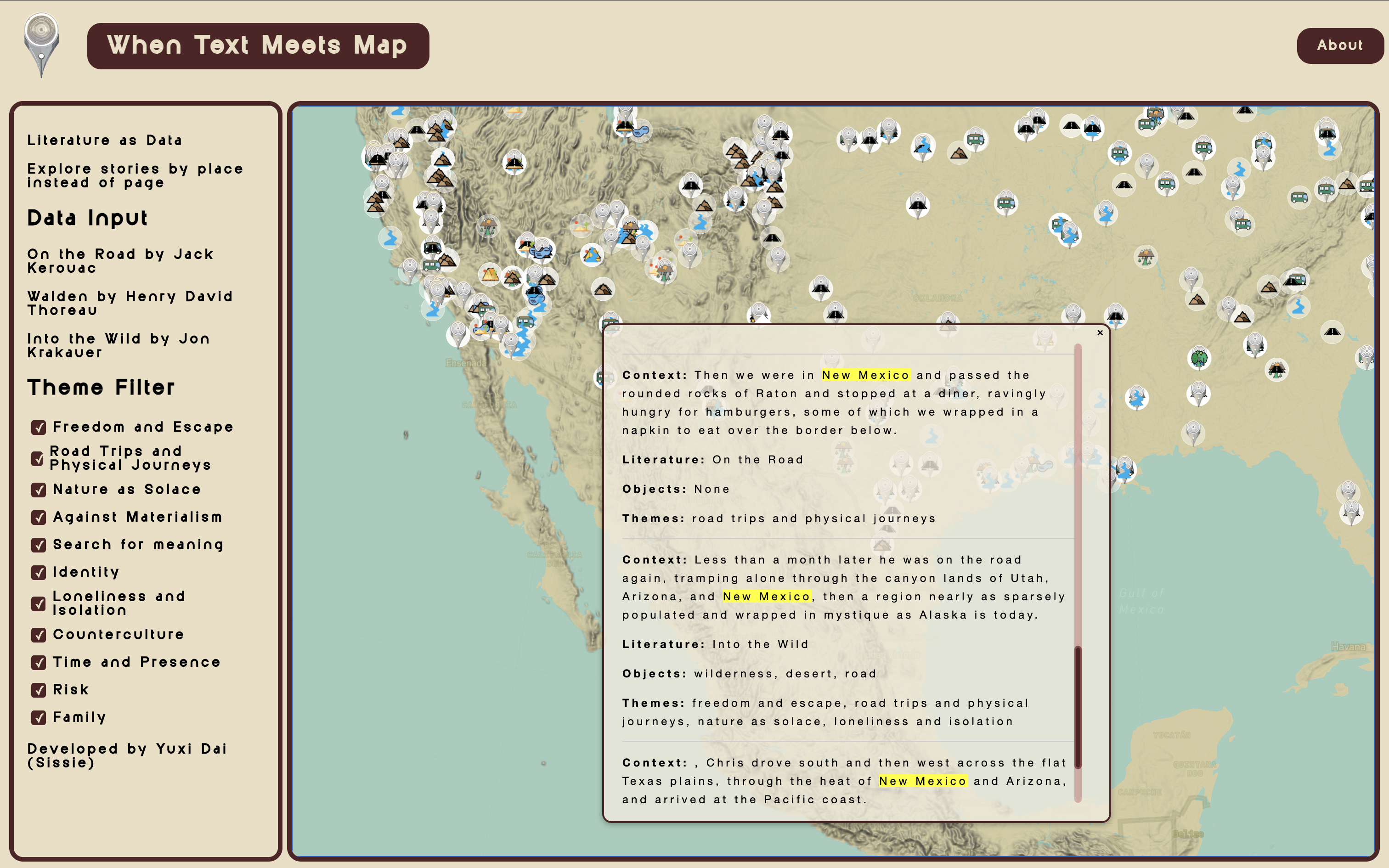
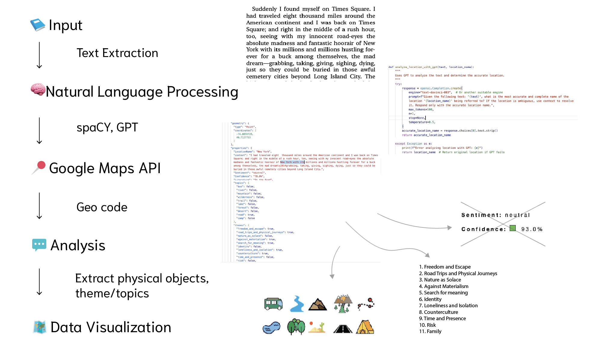
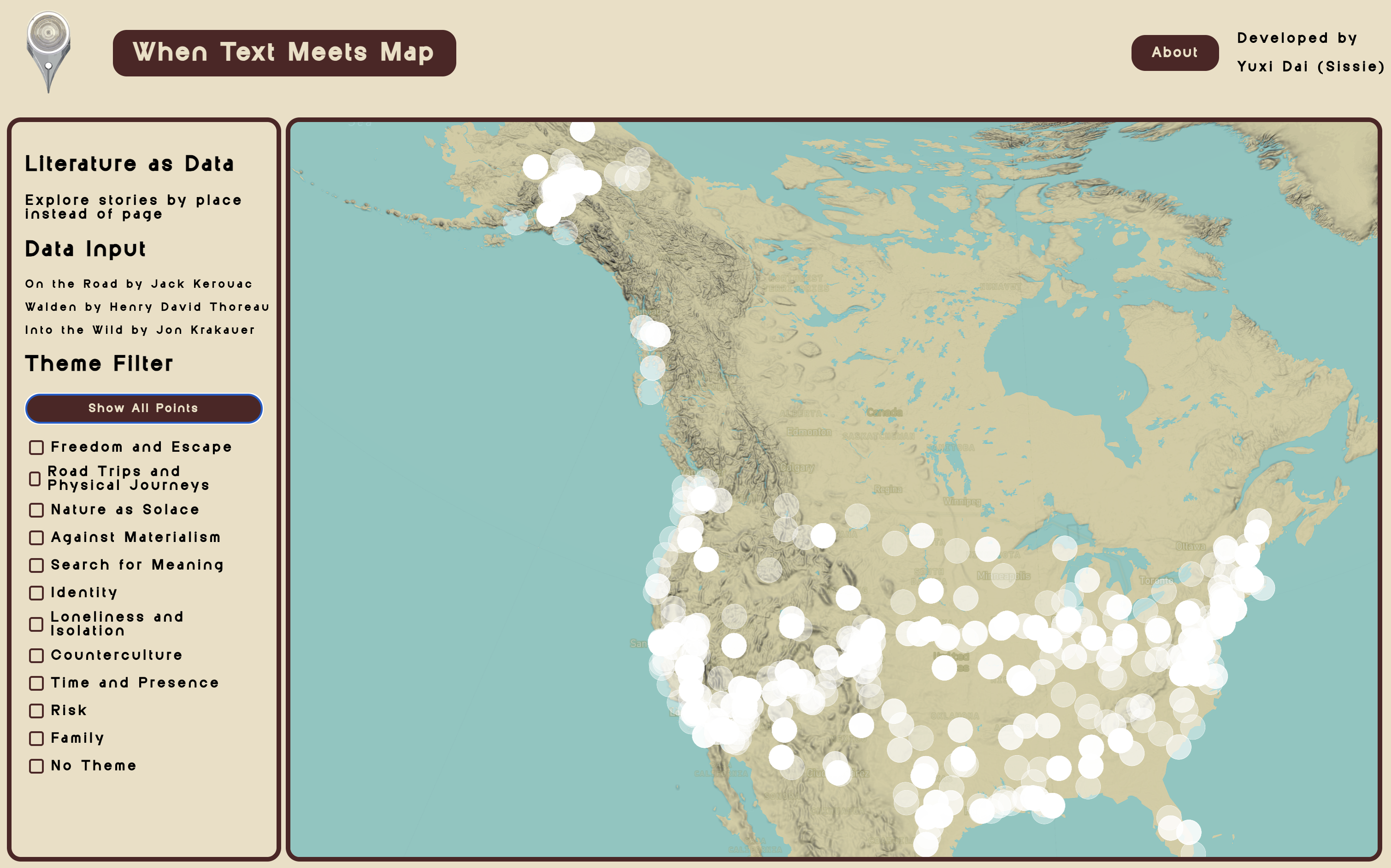
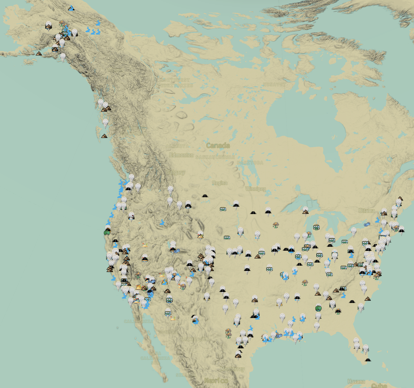
When Text Meets Map
Capstone Project
Memory Tides
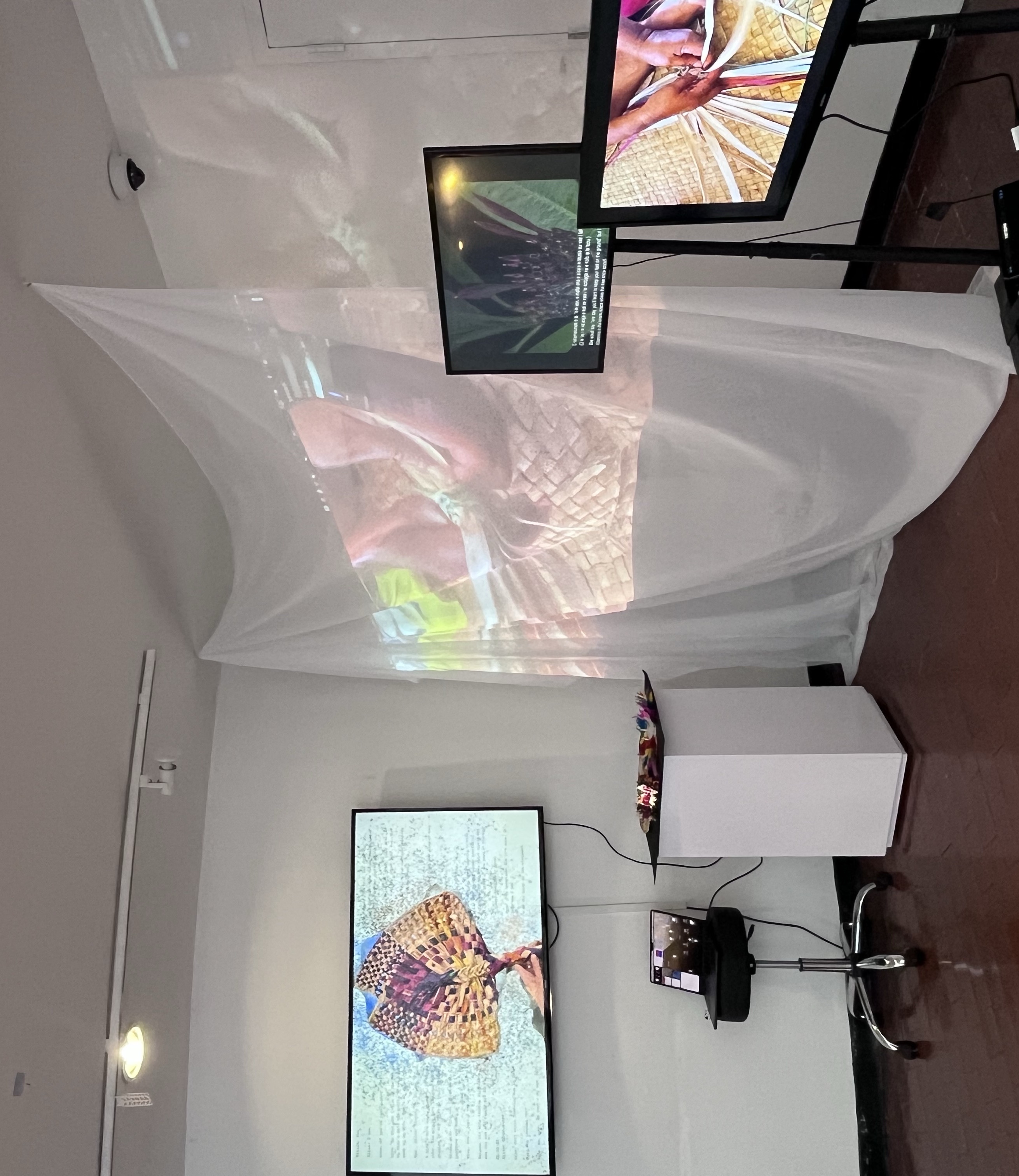
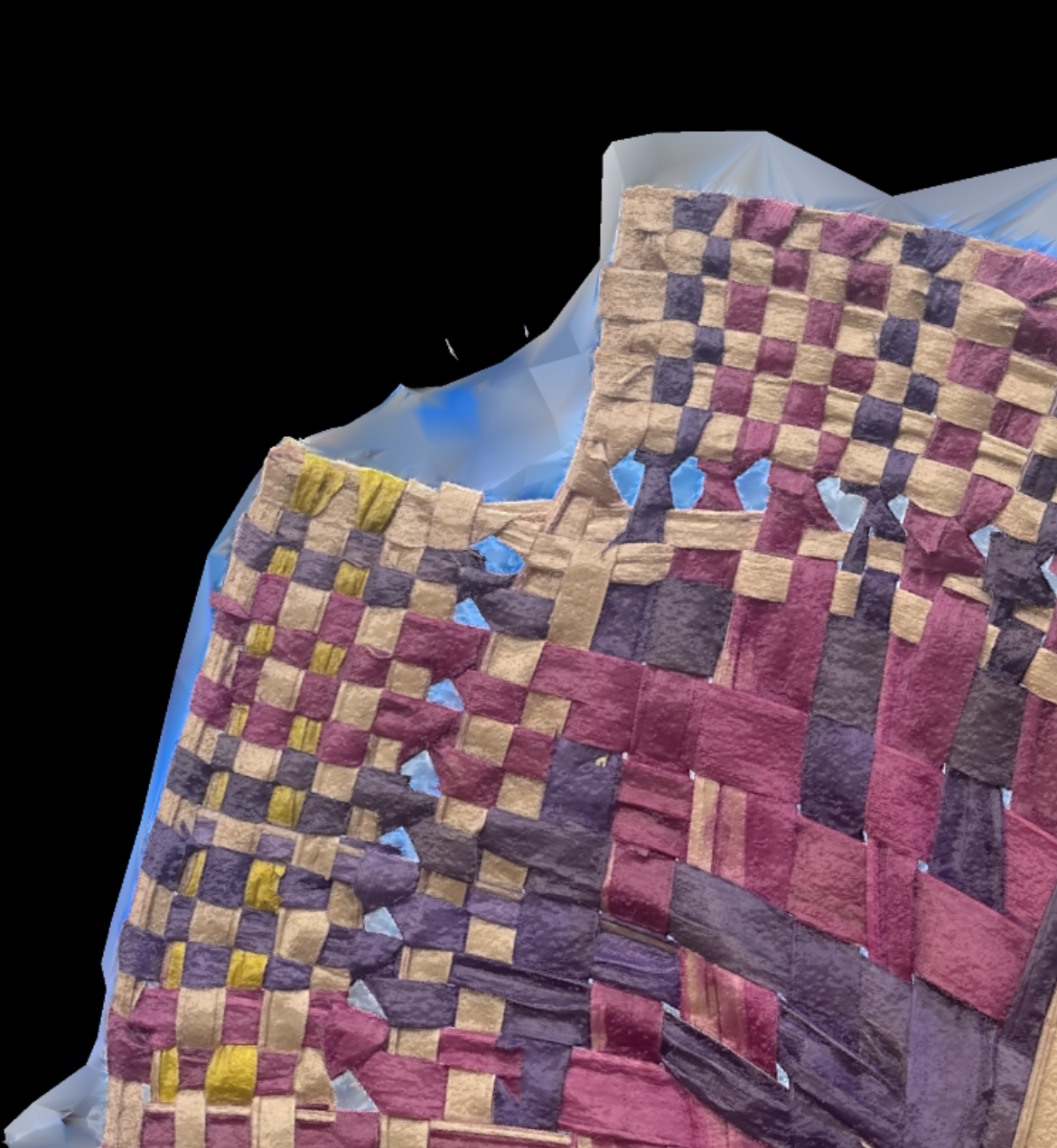
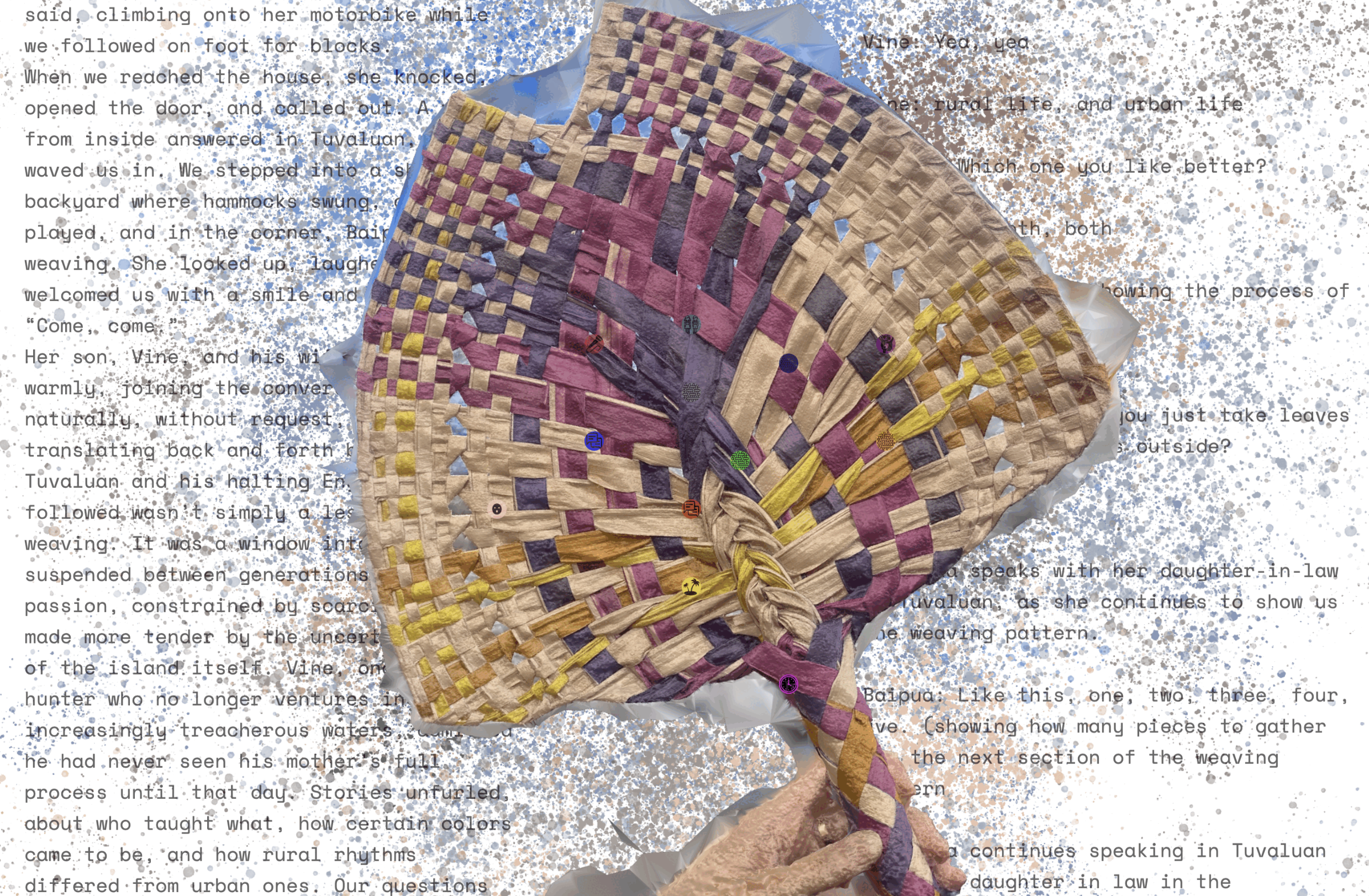
Data Mourning Studio Clinic, Tuvalu
Facade Panelization
Parametric facade logic linked to BIM
Bento
Design Intelligence Project
Terracurve Tower
BIM Workflow, 3D Modeling, Climate Analysis
All Data Are Spatial
Data Visualization Project
Information is power.
Housing Search Process
City Glitch
Urban Design Project, Spatial AI
Soft Data
On-going Project
Project Details:
When Text Meets Map
When Text Meets Map explores the intersection of literature and geography by transforming narrative texts into spatial journeys. The project extracts locations from books such as Walden, On the Road, and Into the Wild, and reimagines them as interactive maps where readers can trace the paths of characters, ideas, and emotions. By aligning narrative structures with geographic data, the project reveals how stories are deeply rooted in place and how landscapes shape the experience of reading.
Through computational text analysis and geospatial visualization, When Text Meets Map turns literary works into dynamic terrains that audiences can navigate. The project reframes storytelling as a spatial experience, inviting users to see texts not only as words on a page, but as lived geographies that unfold across time and space. It highlights how literature both reflects and reconstructs our relationship to the world around us.
The project was exhibited with Spatial Intelligence Association in East Village, NYC.
Software & Skills
- Python & Natural Language Processing
- Named Entity Recognition
- GeoJSON Processing
- Mapbox GL JS
- Interactive Storytelling
- html, css, javascript


Project Info
- Type: Narrative Mapping
- Focus: Data Visualization
- Technology: NPL, Web-based Mapping, AI-assisted Toolkits
- Innovation: Text-Spatial Integration
Memory Tides
Memory Tides is an interactive data-driven installation that maps memories as if they were shifting landscapes. Instead of treating recollections as fixed points in time, the project visualizes them as tidal movements that ebb, overlap, and resurface. By combining computational design with spatial visualization, the work transforms intangible narratives into an immersive environment where memory behaves like water—fluid, layered, and constantly in motion.
Through this dynamic mapping, Memory Tides reframes memory as a living geography rather than a static archive. The project invites audiences to experience how personal and collective histories flow together, revealing the fragile yet enduring nature of remembrance. It suggests that memory is not only something we hold, but also something that holds and reshapes us, much like tides shaping the shoreline.
The installation was also exhibited at e-flux, presented within Marina Otero Verzier: When Pixels Wash Ashore.
Software & Skills
- Python Data Processing
- html, css, javascript
- Projection Mapping
- Interactive Installation Design
- Climate Narrative Research
- Storytelling


Project Info
- Type: Data Mourning Studio
- Location: Tuvalu
- Focus: Climate Change Impact
- Approach: Interactive Storytelling
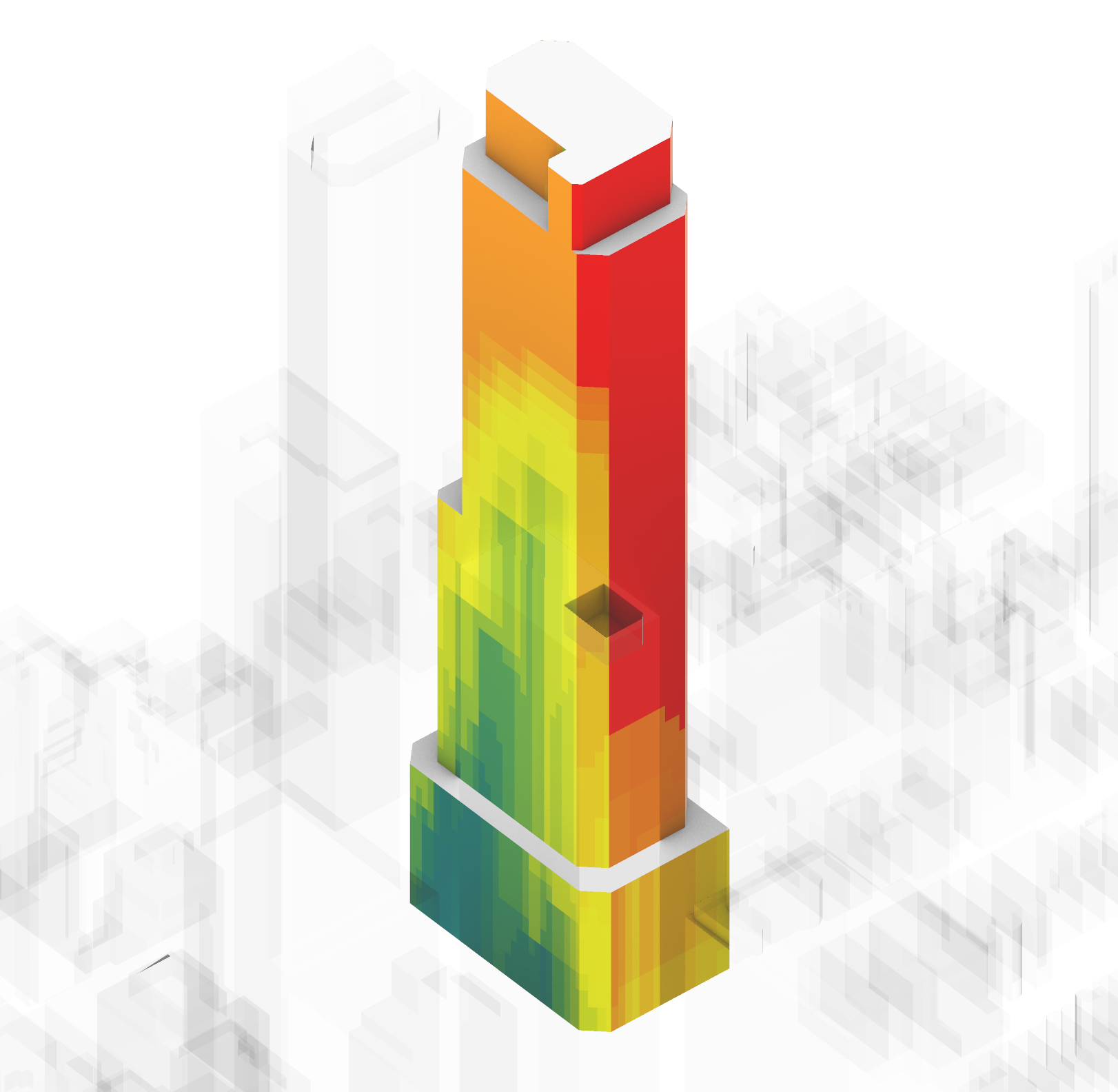
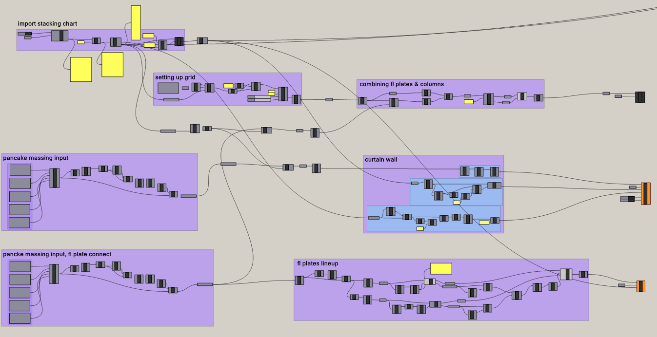
Facade Panelization
This project builds a modular, data-driven facade system that translates environmental analysis directly into panel behavior. Rather than treating performance as a separate layer, daylight and view become active forces in shaping the facade’s expression. The system responds gradually across the building, recognizing shifts in orientation, height, and experience. Views are emphasized on upper levels while daylight continues to inform the overall rhythm of the facade. Through these subtle variations, the building reveals how environmental conditions change across its surface, forming an architectural language that is both responsive and adaptable to future contexts.
The moveable panel system translates these patterns into subtle shifts in openness while maintaining a simple and repeatable construction logic. Standardized panel dimensions and consistent connection details support efficient fabrication and on-site assembly. This balance enables performance-driven design without compromising buildability.
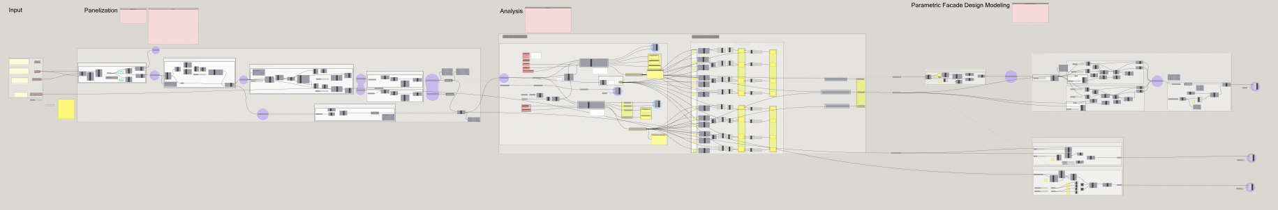
The Grasshopper definition is organized into four main sections: Input, Panelization, Analysis, and Facade Design Modeling. It follows a modular workflow that moves from massing to facade behavior. Users can control the massing, floor levels, context, and panel unit sizes.
Floor level indicators divide the building into horizontal strips, establishing a stable framework for panel generation. Facade geometry is subdivided into repeatable units with consistent dimensions. Environmental analysis is layered onto this structure, allowing panel behavior to respond to daylight hours and view quality. The analysis also provides a clear understanding of how many panels fall within each performance range. Daylight hours serve as the primary driver of the facade logic, while high-quality views are prioritized through a user-defined threshold that triggers wider panel openings.
Software & Skills
- Rhino & Grasshopper
- Facade Optimization
- Data-Driven Prototyping


Project Info
- Type: Parametric Facade Workflow
- Focus: Fabrication-ready panel logic and analysis mapping
- Workflow: Grasshopper drivers linked to BIM documentation
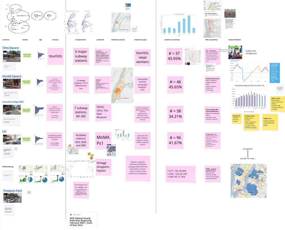
Bento
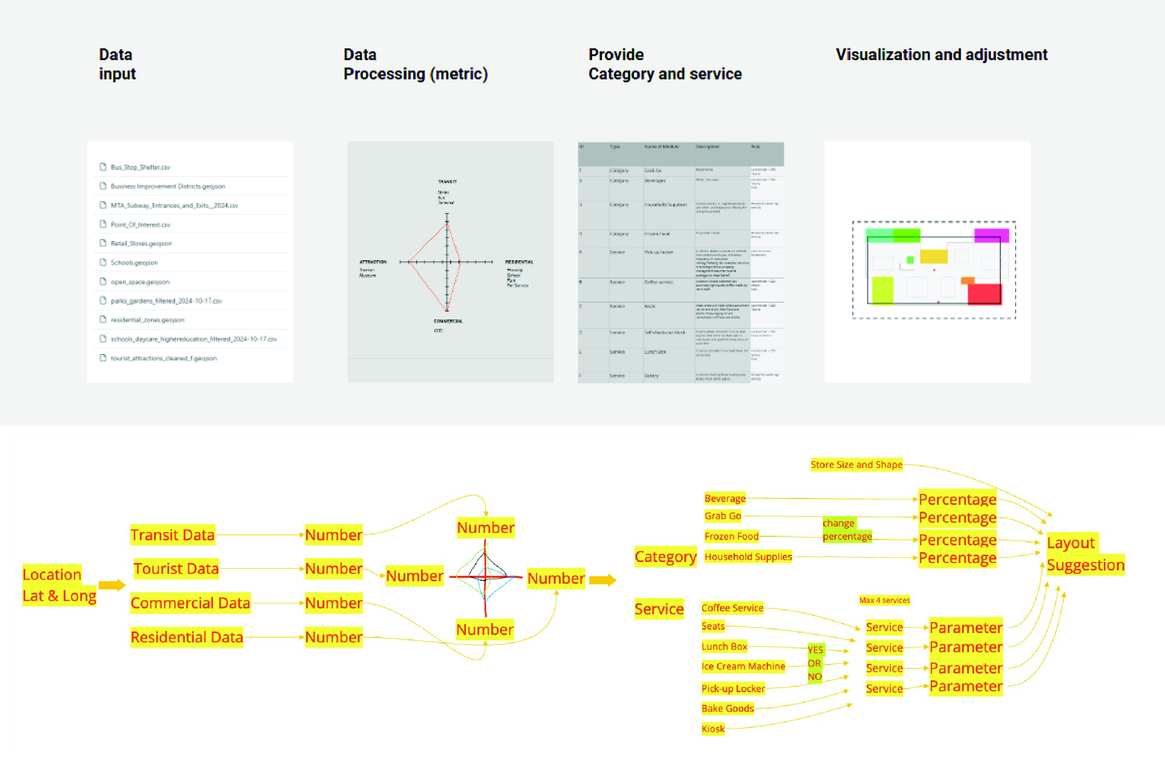
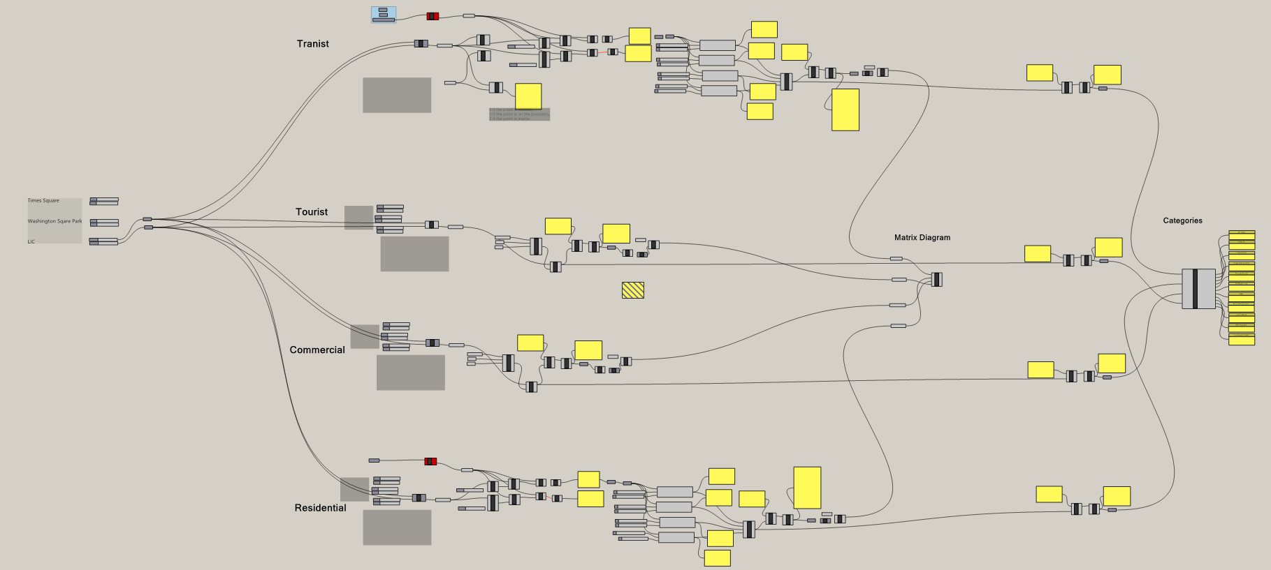
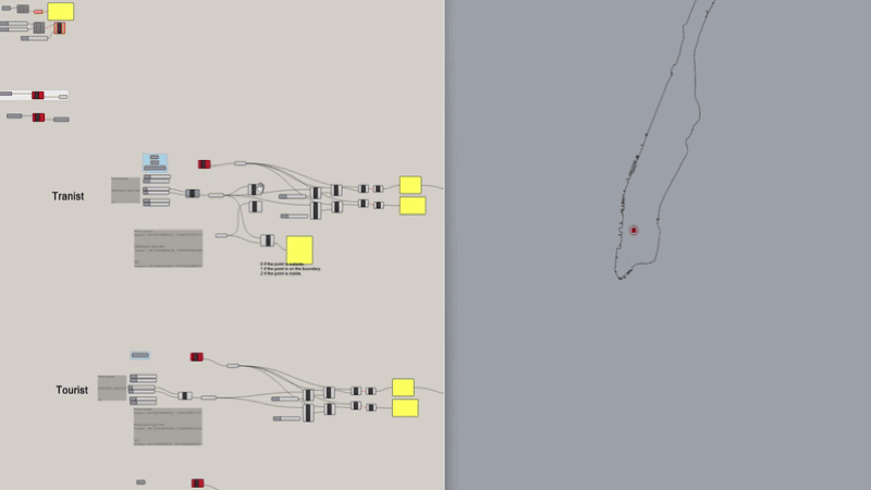
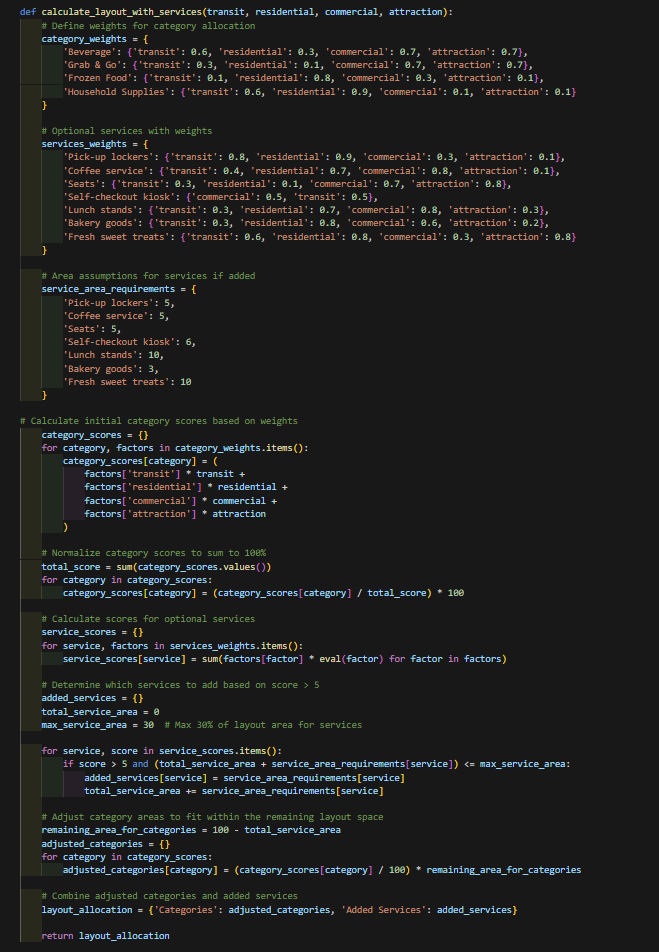
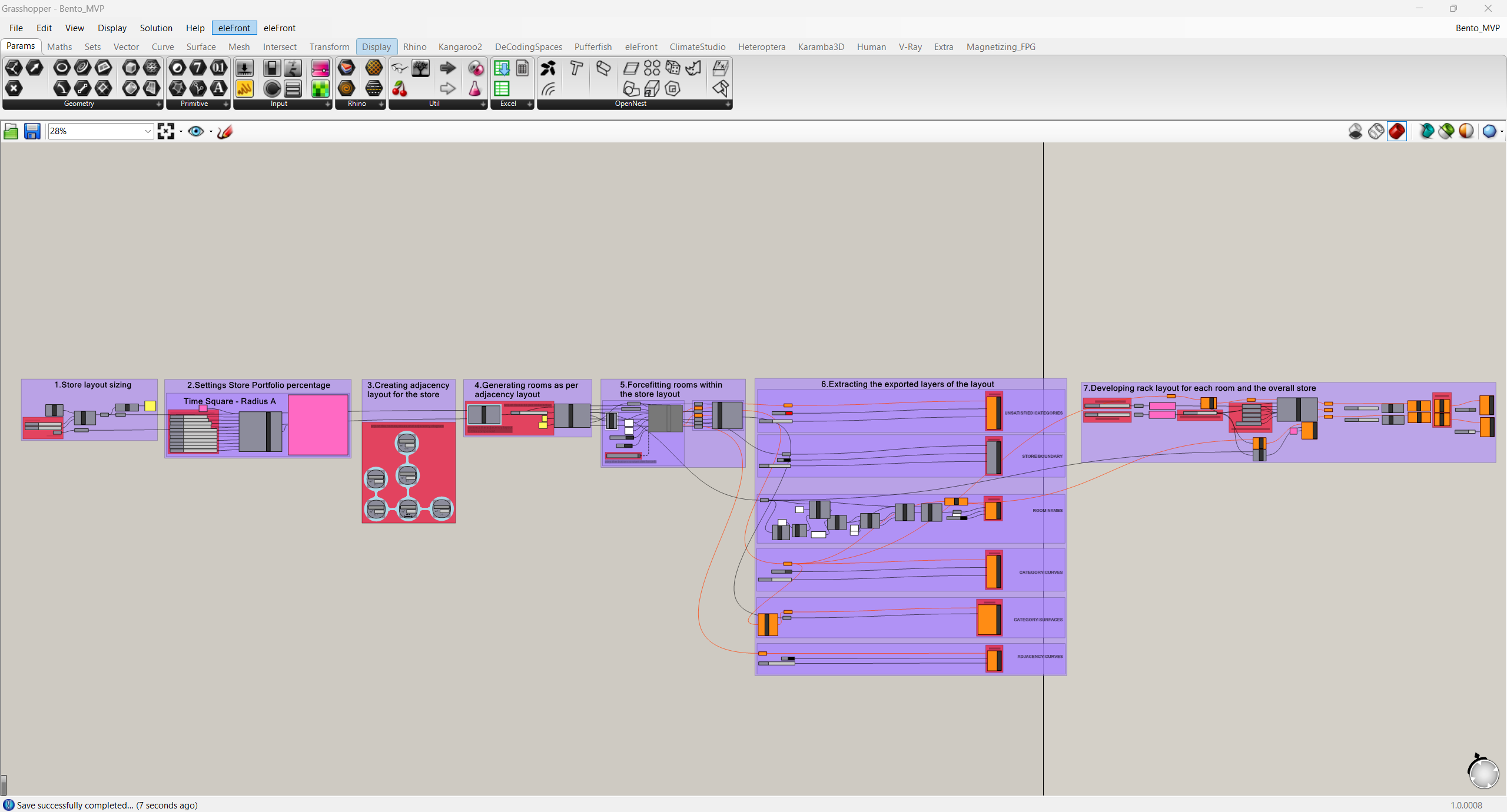
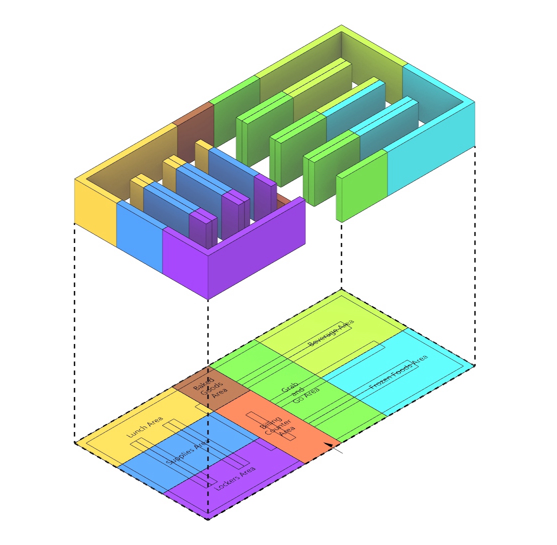
Bento is an experimental project that explores how urban data can inform the design of future retail environments. Using open datasets from New York City, raw information such as CSV and GeoJSON files were processed through Python scripts, cleaned, and transformed into matrix formats for mapping and visualization. This pipeline made visible the spatial and social patterns embedded in consumer behaviors, mobility flows, and neighborhood dynamics. By translating these insights into design strategies, Bento proposes an adaptive retail model that goes beyond static floor plans. The project demonstrates how data can be repurposed as design intelligence, supporting flexible layouts, personalized services, and new forms of community engagement. In doing so, it highlights the potential of computational design to connect architecture, open data, and emerging technologies in shaping responsive and user centered urban experiences.
Software & Skills
- Rhino & Grasshopper
- Python Scripting
- Data Visualization
- Adobe Suites
- Rhino Compute
Project Info
- Fall 2024 Design Intelligent Prof. Danil Nagy
- Type: Design Intelligence Project
- Focus: Data-driven, Future Retail, Adaptive Systems
- Corporate project with Lin Genda, Jain Vaibhav, Ye Zhiqing, Zheng Yilin
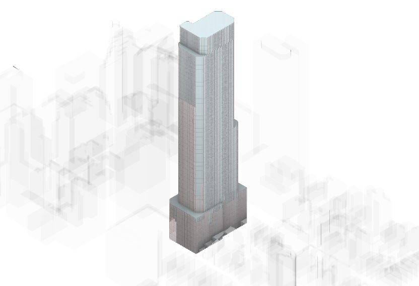
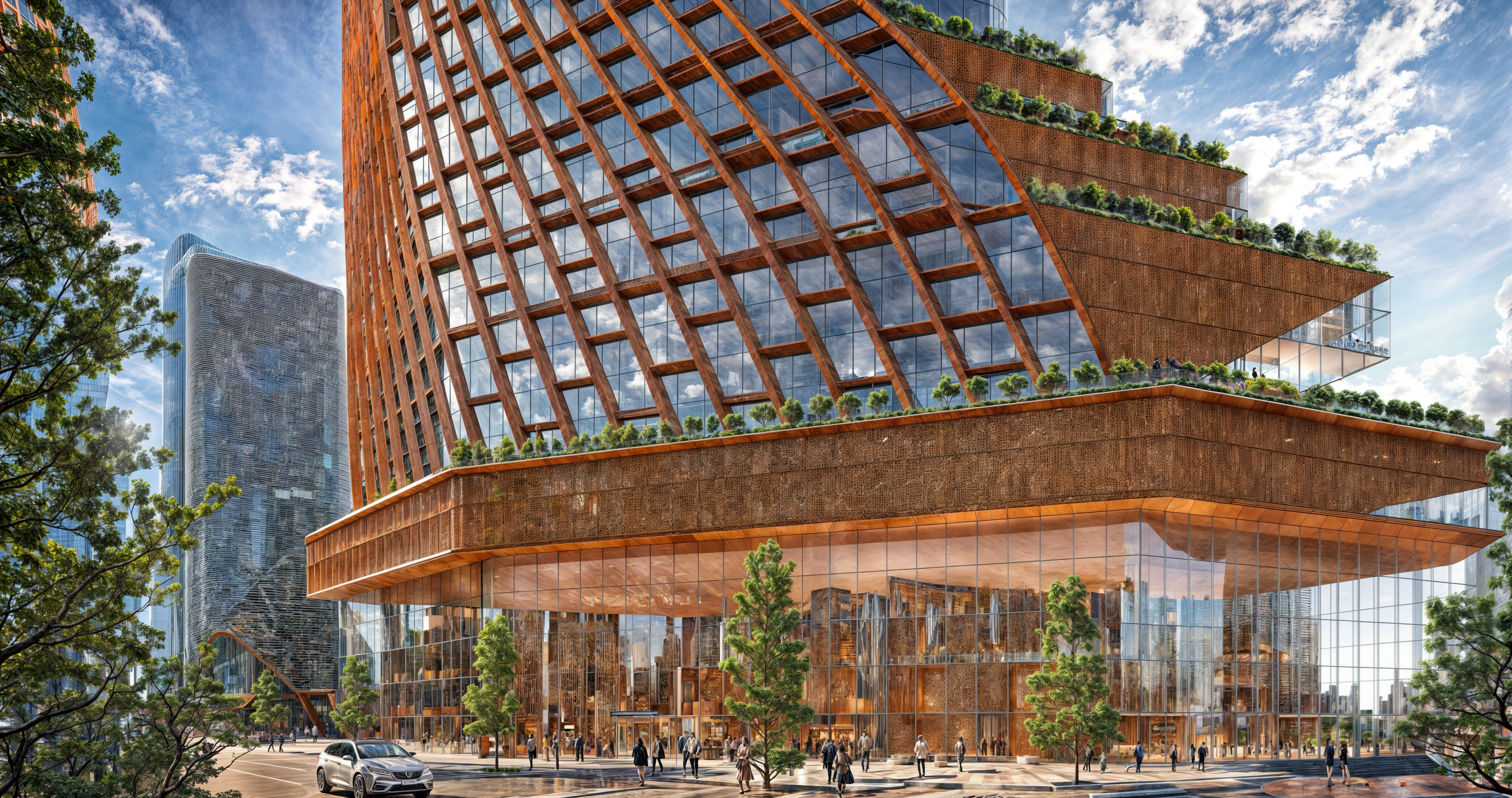
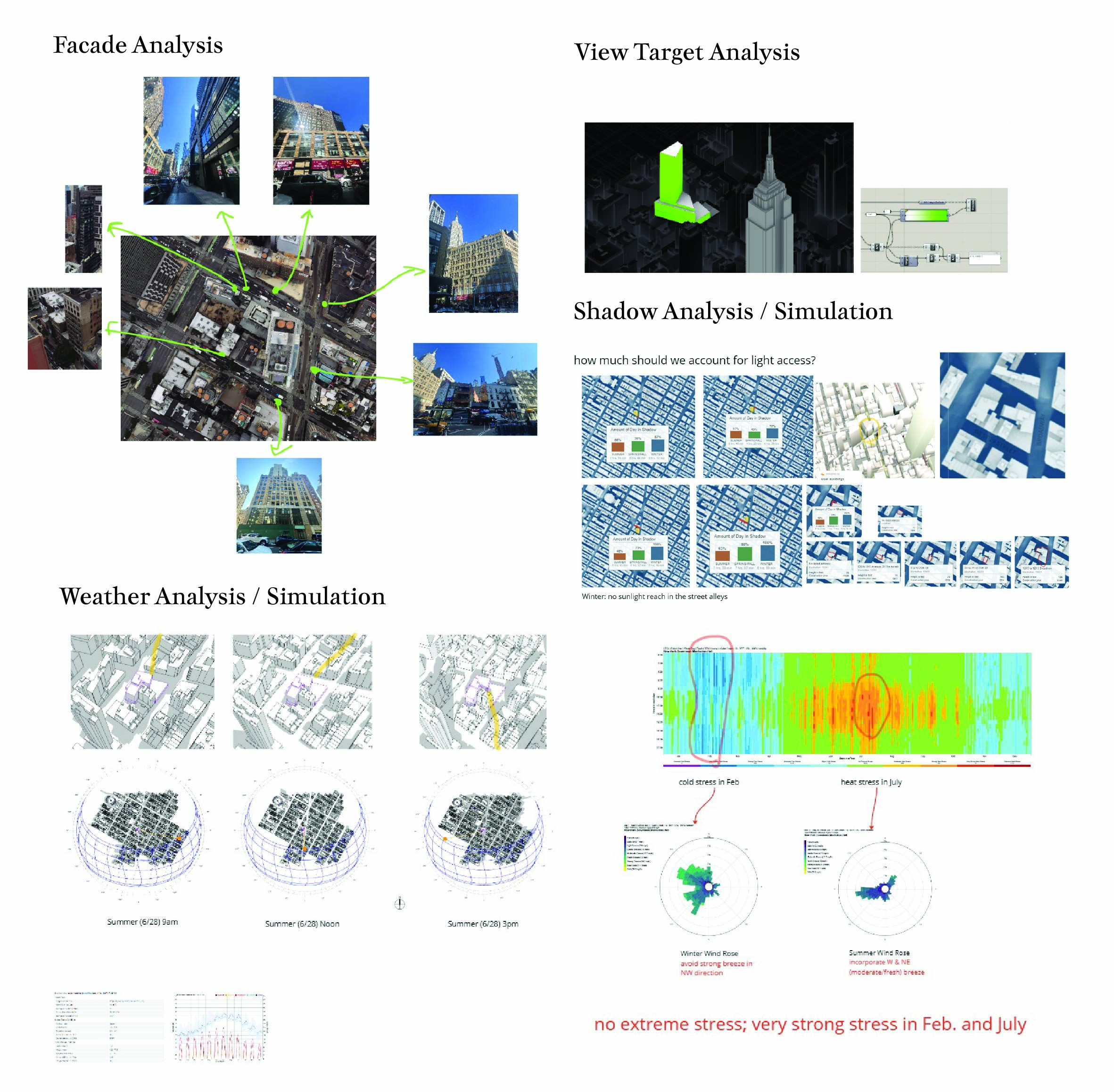
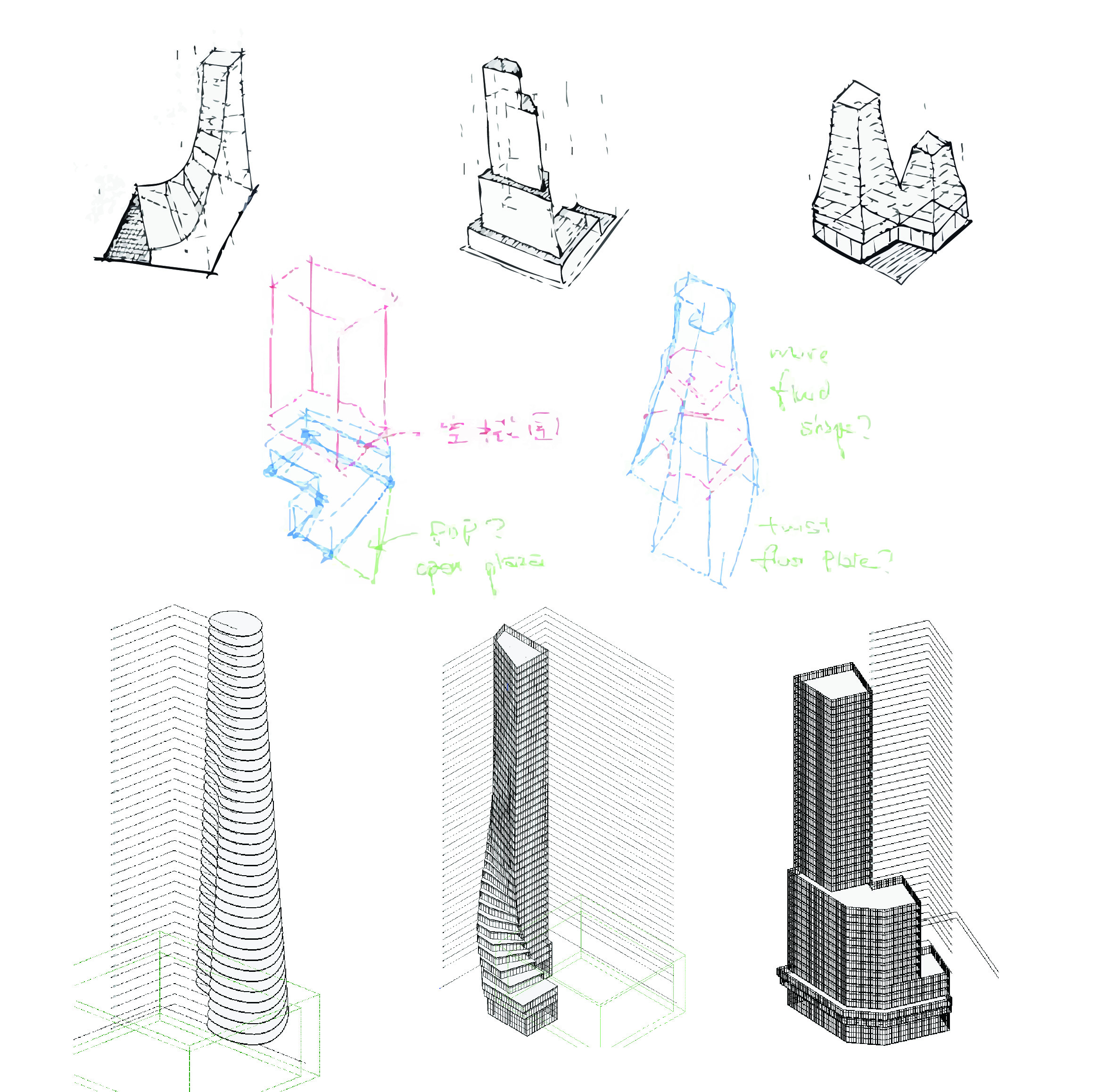
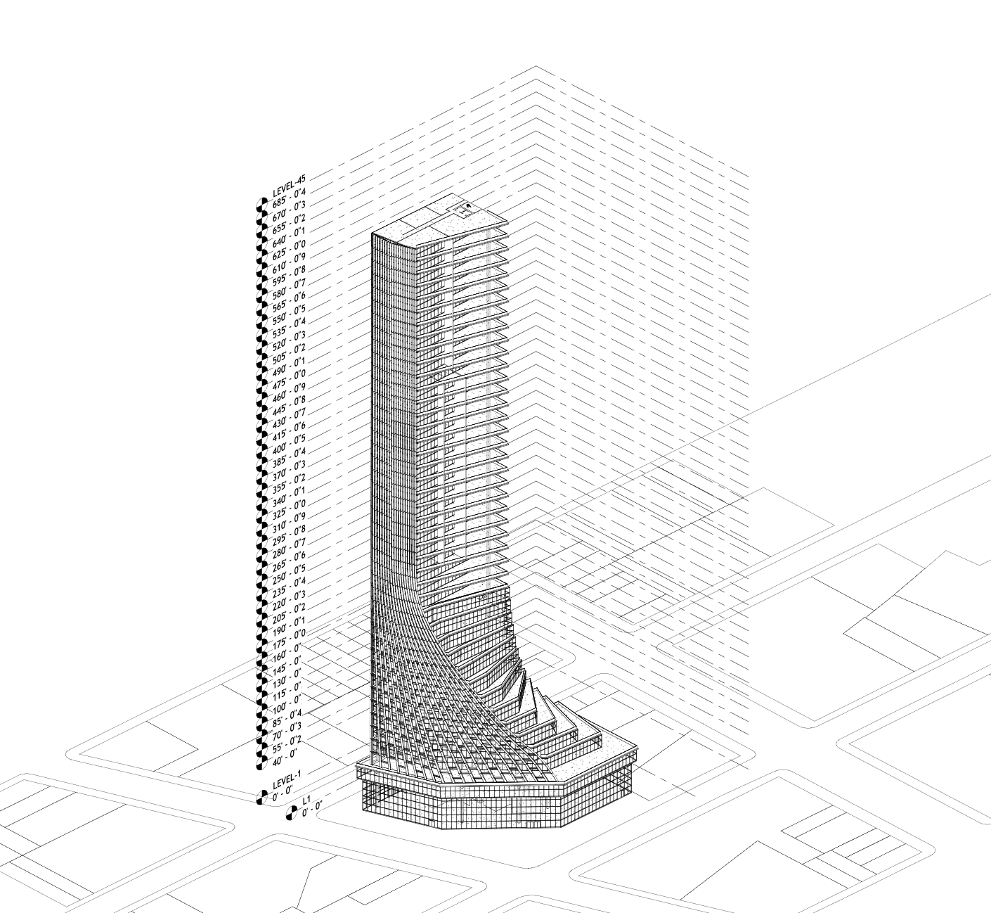
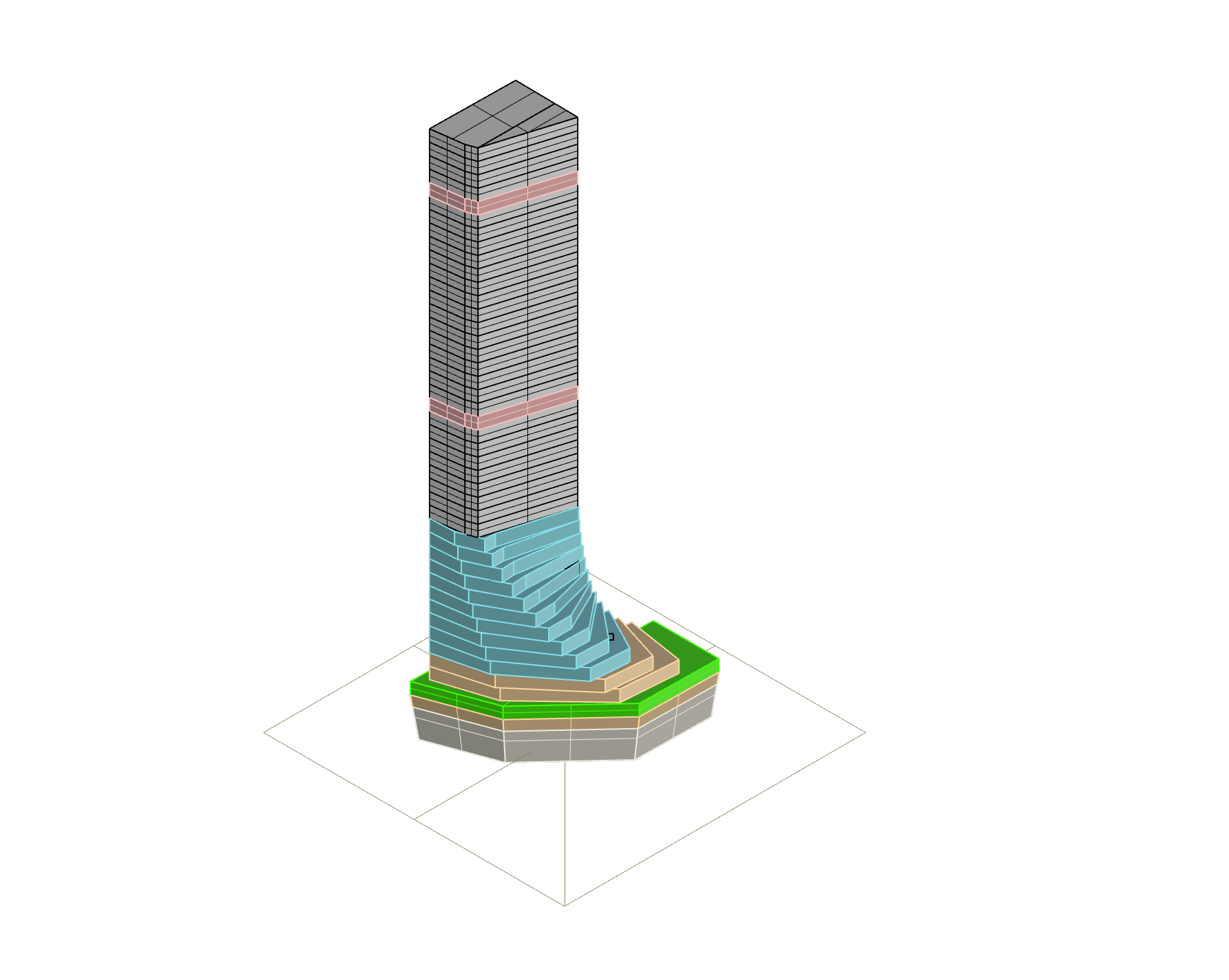
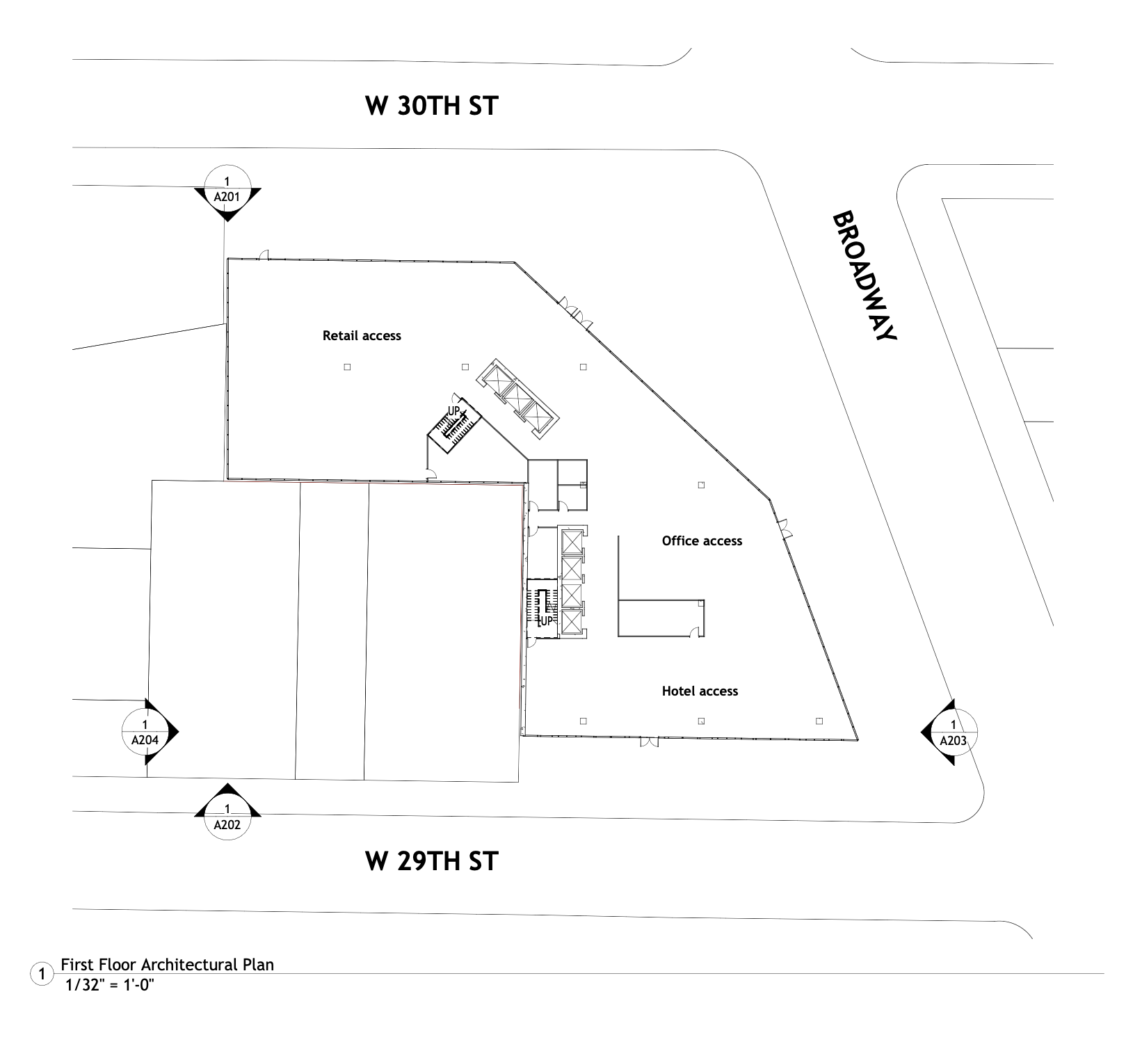
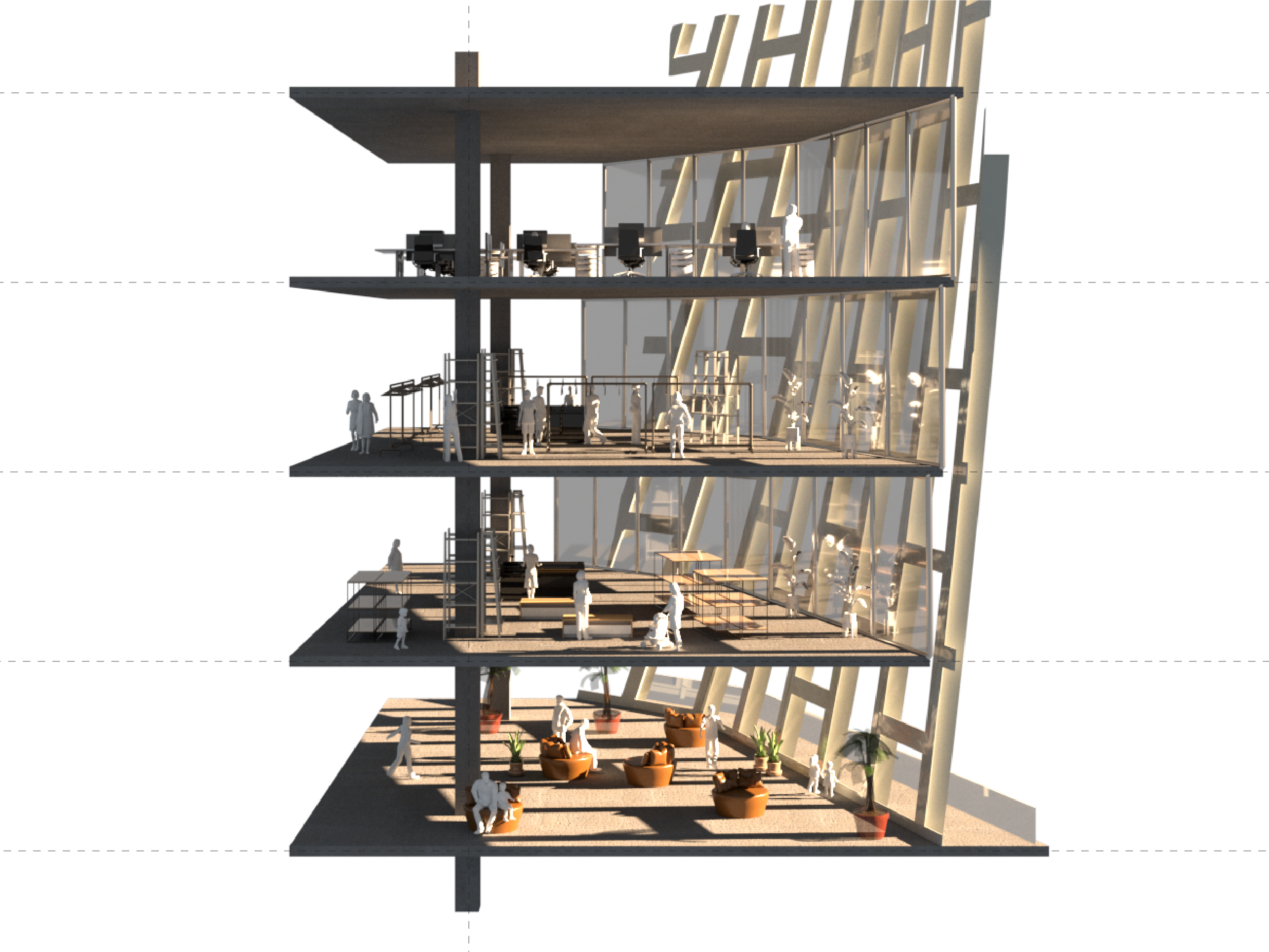
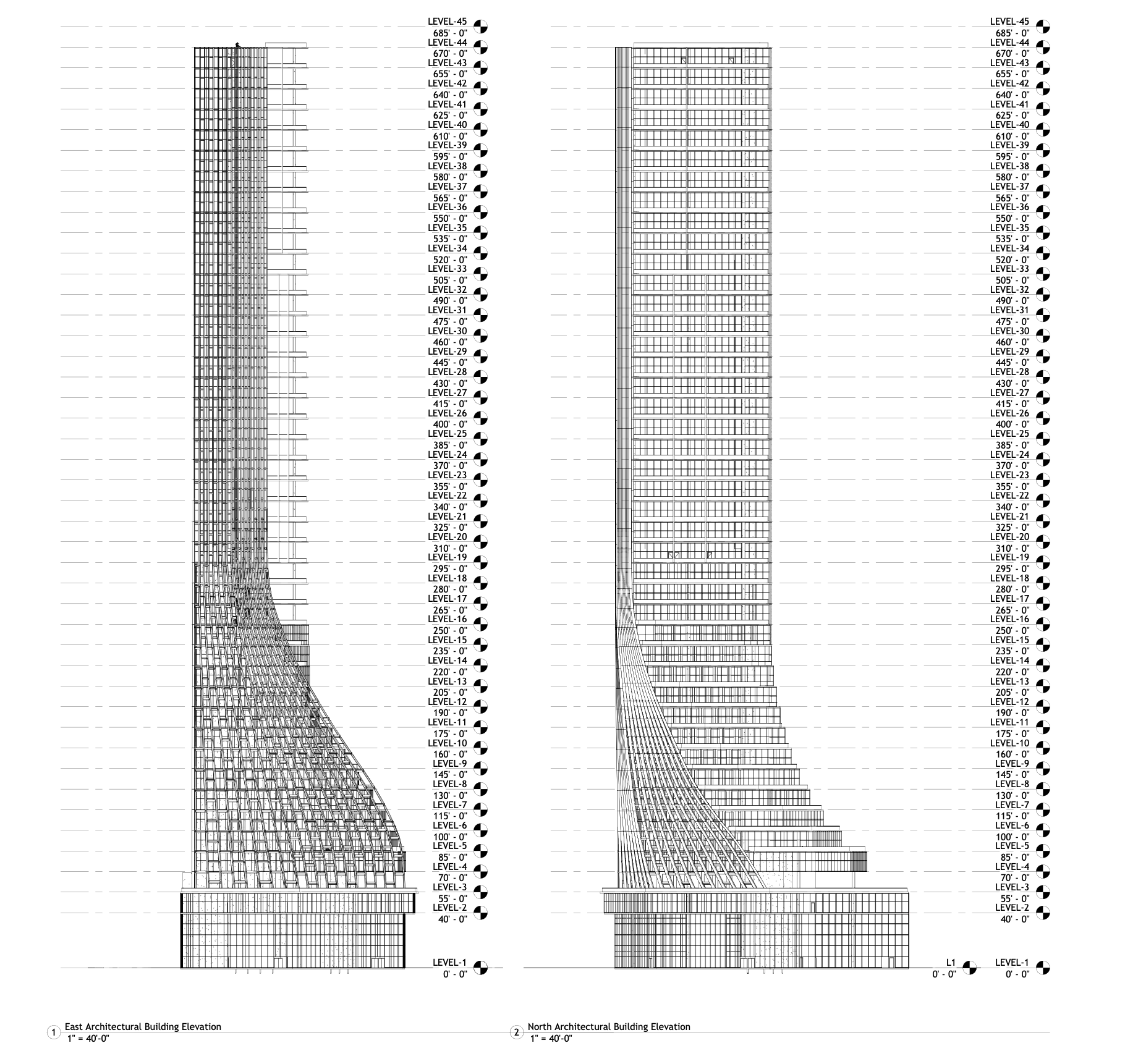
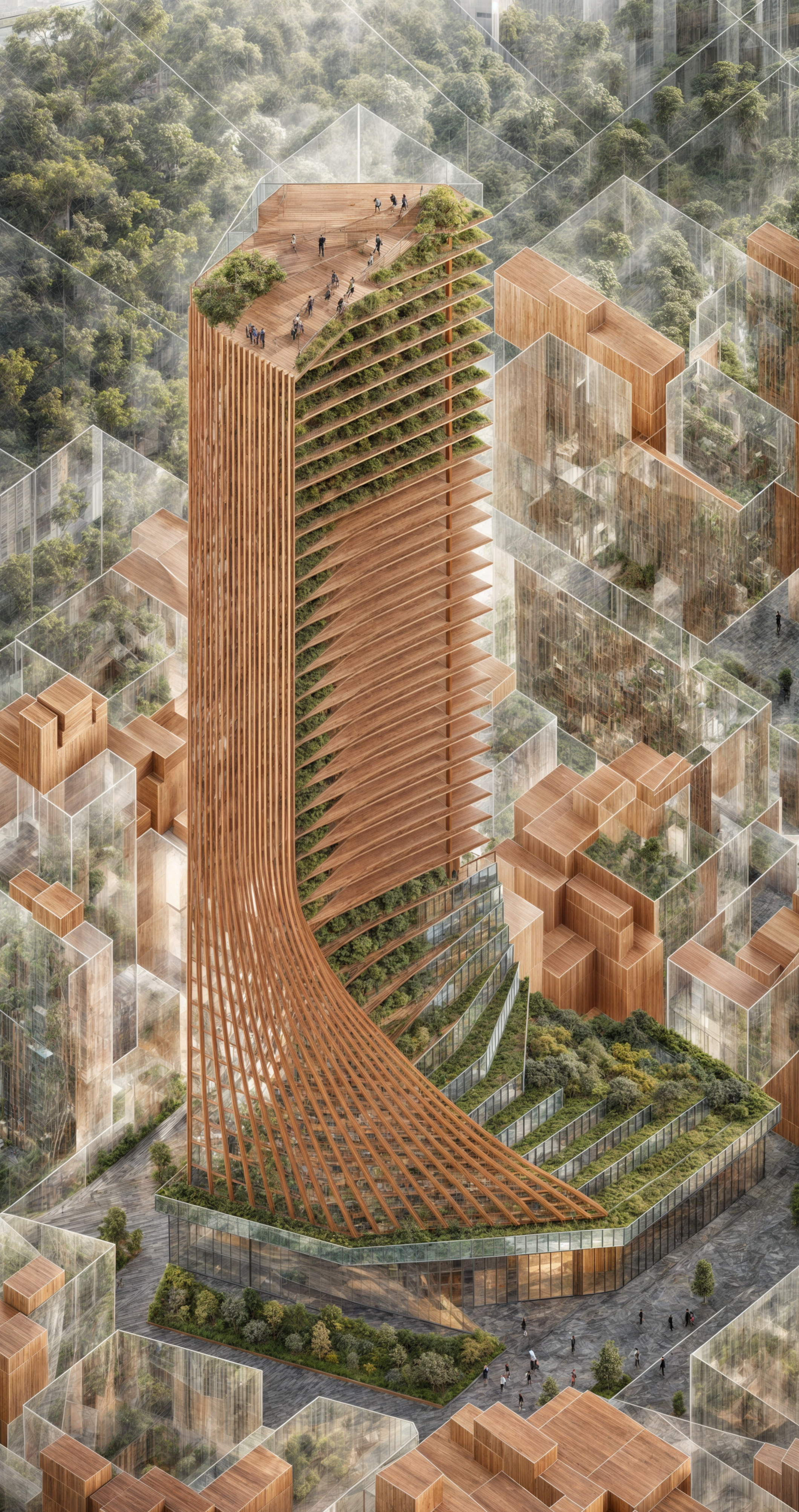
Terracurve Tower
The mixed-use building contains commercial, office, hotel spaces and sustainable transitions between indoor and outdoor environments. A terracotta-to-glass facade, landscaped terraces connecting hotel floors, double-height lobbies, vibrant commercial spaces, and rooftop gardens shape the design.
Used Rhino and Grasshopper for massing studies, target view optimization, and facade design, transitioning effortlessly into Revit with Rhino.Inside.Revit. The project reinforces interdisciplinary workflows and demonstrates advanced BIM integration for precise, innovative execution.
Software & Skills
- Revit & Rhino.Inside
- Rhino & Grasshopper
- Enscape & AI Rendering
- Adobe Suites
- Facade Optimization

Project Info
- Location:1205 Broadway, New York, NY
- Fall 2024 Rethinking BIM: Exploring Interoperability in Design Prof. Joseph A. Brennan
- Type: Mixed-use
- Focus: Environmental Integration & Digital Workflow
- Corporate project with Manas Bhatia / Yilin Zheng
All Data Are Spatial
All Data Are Spatial explores how datasets that seem abstract or purely numerical can be reinterpreted through a geographic lens. The project begins from the premise that every dataset contains a spatial dimension, whether explicit, hidden, or impliedand seeks to uncover these connections by transforming public data into mappable forms. In doing so, it challenges conventional approaches to open data presentation and proposes new ways of perceiving relationships across scales and contexts.
Through computational workflows and interactive mapping, the project translates diverse datasets into geospatial formats, unifying them for greater accessibility and usability. By reframing information spatially, All Data Are Spatial reveals hidden patterns, creates intuitive pathways for exploration, and expands engagement with public knowledge. It is both a critique of existing data infrastructures and a proposition for more transparent, flexible, and spatially aware ecosystems of information.
Software & Skills
- Python Data Wrangling
- QGIS & GIS Analysis
- D3.js Visualization
- Open Data Pipelines
- Spatial Storytelling
Project Info
- Type: Data Visualization
- Focus: Spatial Data Theory
- Innovation: Non-geographic Spatialization
- Application: Universal Data Understanding
Information is power.
Information is Power investigates how information asymmetry shapes housing accessibility. The project focuses on the housing search process, where unequal access to listings, pricing, and availability data determines who secures stable housing and who is excluded. By visualizing patterns in housing market dynamics, it reveals how hidden “information walls” reinforce inequality across urban life.
“Information is power. Access to information enhances one’s power.” — Jo Freeman. This project takes Freeman’s words as a starting point, showing how the uneven distribution of information creates imbalance in opportunity. Data, often presented as neutral, becomes a decisive factor in who has the power to choose, relocate, or remain in place.
“Equal access to resources needed by the group. This is not always perfectly possible, but should be striven for.” — Jo Freeman. Guided by this call, Information is Power insists on breaking the Information Wall, imagining a housing landscape where transparency and open access are not privileges but shared rights. Through computational visualization and spatial analysis, the project reframes data as both barrier and tool—revealing how equitable information-sharing could reshape access to homes and rebalance power within the housing market.
Website: Project Page
Software & Skills
- Python & Pandas
- Housing Market Data Analysis
- Census & Open Data Integration
- Interactive Storytelling
- Data Ethics Research
Project Info
- Type: Housing Search Process
- Focus: Information Asymmetry
- Method: Data Analysis
- Impact: Housing Accessibility
City Glitch
City Glitch reimagines everyday urban passages through data driven analysis and simulation. Centered on Columbus Avenue between 97th and 100th Streets in Manhattan’s Upper West Side, the project frames the street as a dynamic economy of opportunity where static infrastructure such as buildings, sidewalks, and transit stops meets the fluid interactions of pedestrians, vehicles, cyclists, and vendors.
The project asks whether informal uses of space, moments where people adapt their behavior without disrupting flow, can reveal overlooked gaps or hidden potential in city design. By mapping entities and their attributes, simulating actions, and creating an interactive pipeline from data ingestion to web deployment, City Glitch visualizes how formal rules and informal activities converge to expose glitches and opportunities in the design of urban space.
Explore the interactive viewer to add obstacles, agents, and experiment with scenarios.
Software & Skills
- Spatial AI
- Computer Vision
- Python & TensorFlow
- Urban Data Visualization
- Anomaly Detection
Project Info
- Type: Urban Design Project
- Focus: Urban Anomaly Detection
- Course: Professor William Martin, Spatial AI
- Corporate Project with Runqing Xi
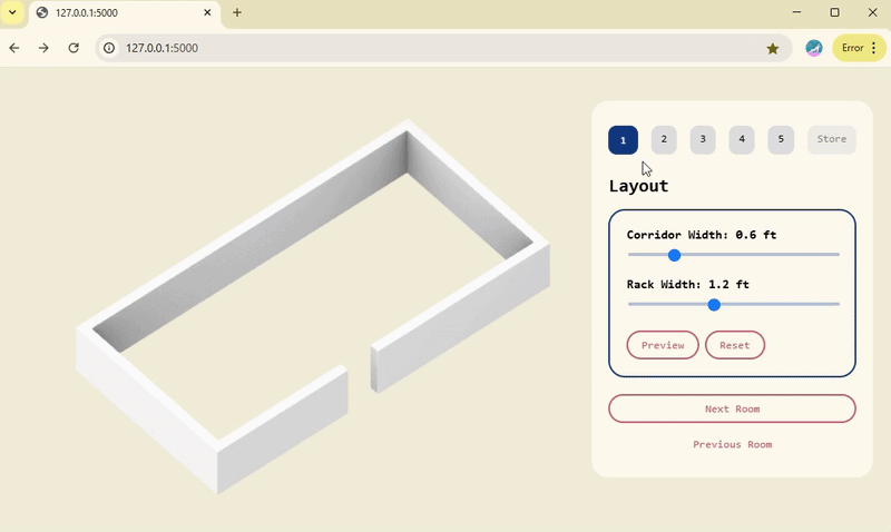
Soft Data - work in progress
Soft Data is an on-going exploration of qualitative signals, narrative inputs, and human-scale observations that complement quantitative datasets in spatial analysis and design.
Software & Skills
- Soft Data Synthesis
- Qualitative Mapping
- Narrative Systems Mapping
- Data-driven & Human-centered Research
- Collaborative Platforms
Project Info
- Status: On-going
- Focus: Soft Data & Spatial Narratives
- Methods: Mixed-method Research